Cycling the Whistler Valley Trail

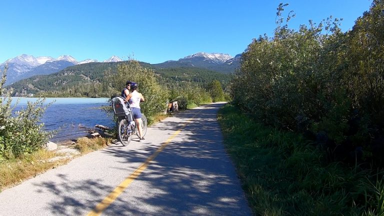
The Valley trails in Whistler, B.C. provide over 40km of maintained multi-use trails connecting Whistler Village to Green Lake to the north, and Function Junction to the south.

Overview of the Whistler Valley Trail system. Download the detailed trail map from Tourism Whistler.

The trails are a mixed of gravel and paved paths which make cycling on them easy for anyone. The trails run through different settings such as within forested areas, alongside a road or lake, or in a meadow like along the hydro cut. The shade provided by the trees along most of the trails make the bike ride reasonably comfortable especially on a warm summer day.

Here are a couple time lapsed videos of my ride on a couple of the main trails.

Driving the British Columbia Coast Mountain Circle Route

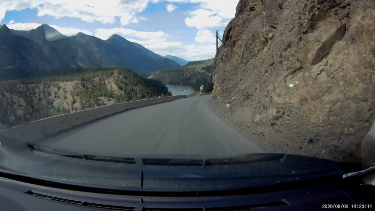
This past B.C. Day, I wanted to get out of Metro Vancouver, where I’ve been “stuck” for the past five months, but I only had the one day free to do it. I was debating whether to do a trip up north to Whistler, or to the east to Manning Park (pretty much the only two directions one can drive from Vancouver. However, I’ve been to both of these places. I wanted to explore something new.

I remembered that I had wanted to do the Coast Mountain Circle Route, the smallest “loop” that one can make going out of Metro Vancouver one direction and coming back another direction.

For a description of the different communities along the way, see the Tourism BC website. This route travels through both the scenic Fraser Canyon, and the Sea to Sky.

Most of the guides I’ve seen on the Internet suggest travelling in a clockwise direction. I elected to drive it counter-clockwise, because I am familiar with the Sea to Sky section so I wanted to see the Fraser Canyon section in the daytime for sure.

I’ve actually driven portions of this from Vancouver to Pemberton to the north, and from Vancouver to Lytton to the north east, so the section completely new to me was the part from Lytton to Lillooet back to Pemberton, roughly 2.5 hours out of the total 10 hour drive.

Since I only had one day, I didn’t plan to stop for long in any of the places. Also due to the COVID-19 pandemic, I wanted to keep to myself as much as possible, so brought my own food and pretty much only stopped to fill up gas and to use restrooms, or some photo ops around the car.

This is the dashcam video of the entire trip:

There’s definitely a lot to see along the way, so I am looking forward to driving this loop again making more stops along the way.

Whistler Ski Run Topographic Map

My cousins from Toronto came over to ski and snowboard at Whistler over the last month.  I had the opportunity to pick up skiing again and accompany them up at Whistler a few times.

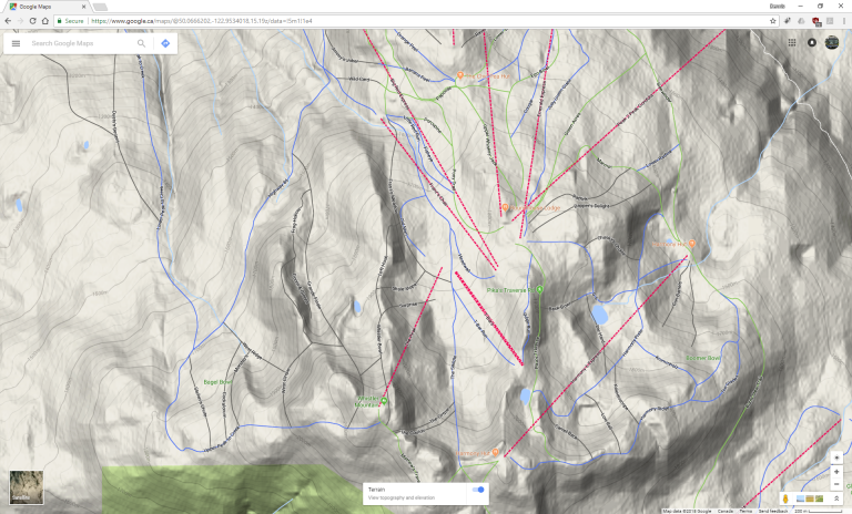
Whistler Blackcomb is pretty big, so one would usually look at a map to find suitable runs.  This is a sample of what is provided in the “Mountain Atlas”:

A portion of the official Trail Map/Mountain Atlas you get from Whistler Blackcomb

It looks nice and is mostly useful.  But for all the map geeks out there, can we find anything better?

Turns out that Google Maps conveniently has the ski runs in its map.  But there’s more: Google Maps in Terrain mode shows the contour lines like a topographic map!

“Topographic” map of Whistler Mountain (north is upwards — so the Village is towards the top)

Beautiful!  The top-down view makes it easy to see the actual orientation of the run and “behind” the mountains, and the contour lines makes the rate of descent visible.  So from here you can see there is a green run from the Peak—Mathew’s Traverse—whereas it’s not depicted on the trail map.

How do you get to the map?

Here’s the link: Google Maps Terrain @ Whistler
Alternatively you can search for the location you want in Google Maps, then open the menu at the top left, then select “Terrain” mode.

Terrain is one of the layers in Google Maps

Transit highlights from my Toronto trip

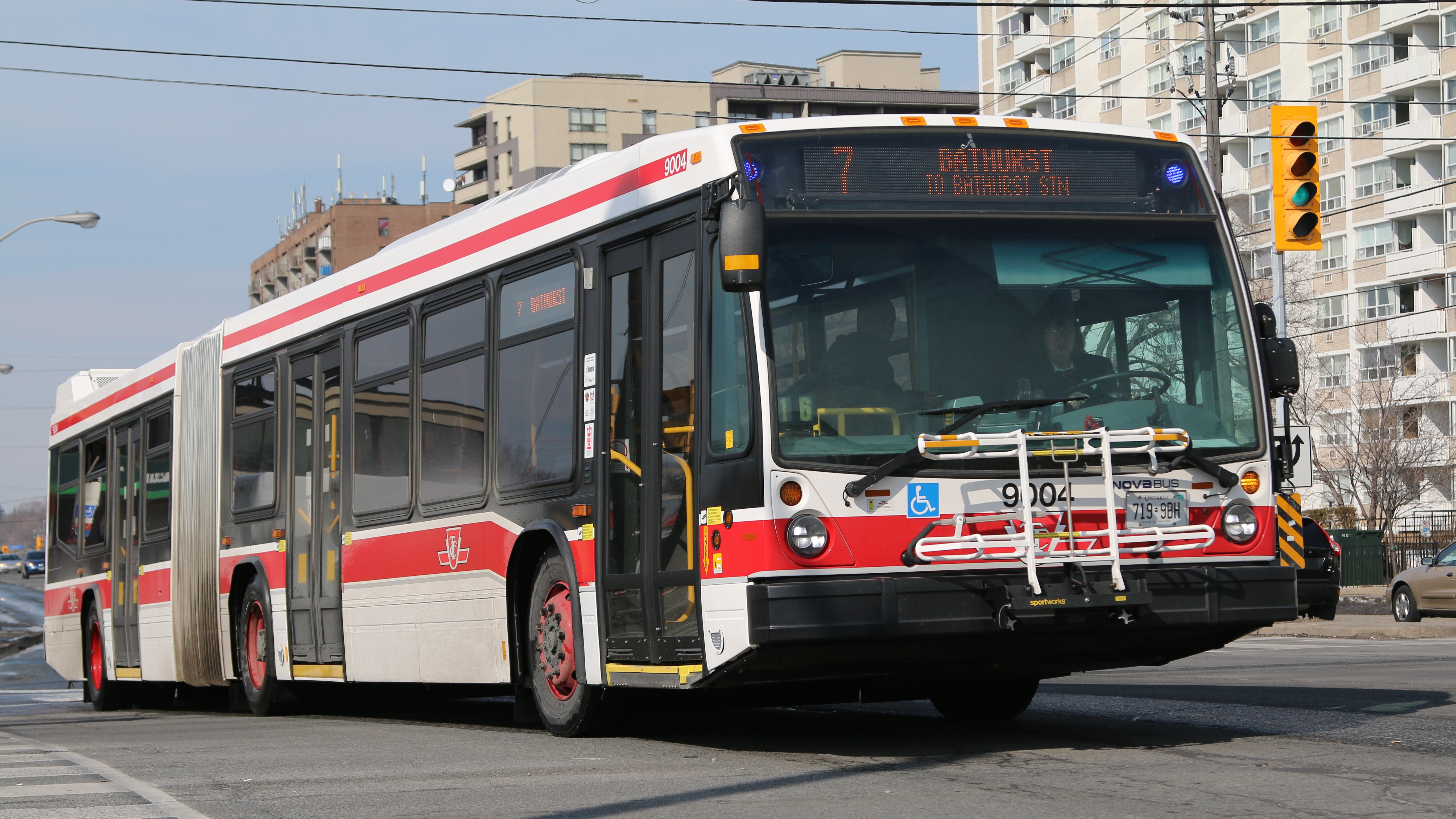
While I was in Toronto these past few days, I got a chance to see two of Toronto Transit Commission’s (TTC) newest transit vehicles.

For those unfamiliar with public transportation in the Greater Toronto Area, a number of transit authorities provide local transit service within different regions in the GTA.  The TTC provides transportation services within the Toronto proper, including the subways, streetcars and bus service.  I suppose a more detailed introduction to the different public transportation services would be ideal in a separate post.

The articulated buses

The first were the Nova Bus LFS articulated buses. These buses, introduced mid-last year, were the first articulated buses in the TTC fleet since 2003. This one was seen on the #7 Bathurst line.

TTC 2013 Nova Bus LFS Articulated Bus #9004 on the #7 Bathurst line

I must give credit to an Android app called Transit Now Toronto for helping me find out when the articulated buses were coming down the line. I actually did not realize that TTC had real-time arrival data available, so actually I spent half the time trying to find these buses the “old-school way”.

The new streetcars

The second was one of the new streetcars. This was a bit of a lucky catch as I was at Bathurst station originally looking for the Nova Bus articulated buses. When I was coming up from the subway as I saw the streetcar demonstrator pulling through the streetcar loop. I would have liked to chase it further for better photos, but my time was constrained.

TTC 2013 Bombardier Flexity Outlook Demonstrator #4401 at Bathurst Station

The new Toronto streetcars are built by Bombardier, and are similar to the ones that were demonstrated here in Vancouver during the Olympics. A fleet of 204 Flexity Outlook units have been ordered and are replacing the aging fleet of CLRV and ALRV streetcars that were built in the 1970s and 1980s.

The weather

On an unrelated topic, the weather in Toronto was very forgiving while I was there. I was hoping to see some real snow fall, but the weather turned out to be “relatively warm” (by Toronto standards); on some days it was even sunny. So before my flight back, my cousin took me to the largest (manmade) snow mound he knew of. I climbed on top of it just for kicks.

Me on a mound of snow. Yes apparently it’s all snow, I’m assuming the land here was flat before they started piling the snow up here.

Exit mobile version